The history of cartography traces humanity’s relentless quest to understand and depict the world around us. From ancient civilizations sketching rudimentary maps to modern digital cartography, this journey has been marked by innovation, exploration, and cultural exchange. Early maps served practical purposes like navigation and land management, while also reflecting religious beliefs and political power dynamics. Over millennia, cartography evolved through the contributions of diverse cultures, from the Babylonians and Greeks to the Renaissance cartographers and contemporary GIS specialists. To understand the history of maps is to understand mankind’s love of exploration and to understand its place in the world.
- Study by Yale University Experts Proves Vinland Map is a Hoax
- Magic Mountains and Sea Serpents: The Secrets of Early Arctic Maps
The History of Maps – From Mammoth Tusks to Satellites
Go back far enough and it can be hard to tell whether an artifact was originally meant to serve as a “map” or something else. Indeed, the very definition of a map isn’t that precise. This means there’s quite a bit of competition when it comes to being the “earliest known map”. Still, there are a handful of contenders.
- A carved mammoth tusk believed to date back to around 25,000 BC has been found. It is covered in a map-like representation of the topological features of the area surrounding Pavlov in the Czech Republic.
- The next contender is slightly younger, an Aboriginal Australian cyclon (cared cylindrical stone) dating back to around 20,000 years ago. Its carvings are believed to depict the Darling River in Australia.
- A Mammoth bone found at Mezhyrich in Ukraine has something resembling a map etched on it. It’s around 15,000 years old.
- The walls of the Lascaux caves in France feature dots that appear to map parts of the night sky, including three stars: Vega, Deneb, and Altair as well as the Pleiades star cluster. These are believed to be around fourteen and a half years old. The Cuevas de El Castillo in Spain contains a similar dot map thought to date back to 12,000 BC.
- One of the most controversial contenders for a presentation that we might consider a map today is an ancient picture created in the seventh millennium BC found in Çatalhöyük, Anatolia, modern Turkey. It’s a wall painting thought to map out a Neolithic village in the region. However, there’s some debate as to whether this counts as a map or just a painting of a village.
Whether are not these early examples count as maps or works of art largely depends on whom you ask. Still, at the very least they’re proof that human attempts to understand and map out their surroundings go back thousands, if not tens of thousands of years.
- Charles Hapgood and the Maps of the Ancient Sea Kings
- The Buache Map: A Controversial Map That Shows Antarctica Without Ice
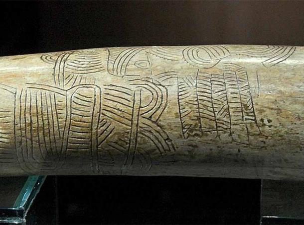
Engraving on a mammoth tusk perhaps representing a “map”, Pavlov (Břeclav DIstrict, Southern Moravia, Chech Republic). This engraving may well be the oldest known representation of a landscape. (Zde/CC BY-SA 4.0)
Maps of the Ancient World: Babylonians
In the ancient world, the origins of cartography can be traced back to civilizations like Babylon, where some of the oldest known maps were created. The Babylonians are known to have used surprisingly accurate surveying techniques. A clay tablet found at Ga-Sur in 1930 shows a map of a river valley in the region with cuneiform inscriptions labeling unique features, including owned plots of land.
This particular map is believed to date back to 2500-2400 BC and features topological features like hills shown by overlapping semicircles, rivers by lines, and cities by circles. Another Babylonian map, this time dating back to the Kassite period (fourteenth–twelfth centuries BC), is much narrower in focus, showing the walls and buildings of the holy city of Nippur.
There’s even a Babylonian World Map, arguably the earliest surviving map of the world, from 600 BC. However, the mapmakers made little effort to be accurate and knowingly omitted the Persians and Egyptians. The map shows the world as a circular shape surrounded by water and was likely designed to fit the religious image that the Babylonians believed in.
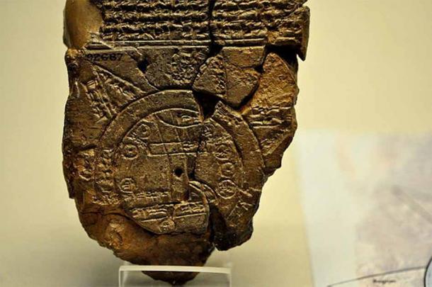
A close-up view of the Babylonian map of the World. This partially broken clay tablet contains both cuneiform inscriptions and a unique map of the Mesopotamian world. Probably from Sippar, Mesopotamia, Iraq. 700-500 BC, at the British Museum, London. (Osama Shukir Muhammed Amin FRCP(Glasg)/CC BY-SA 4.0)
Greeks and Romans
Ancient Greek civilization also played a key role in the development of cartography. It’s believed the first maps to be drawn on a form of paper rather than on stone or clay were Greek. Notable figures like Anaximander, Hecataeus, Herodotus, and Eratosthenes were all key to Greek advancements in cartography.
Though lost to time, some historians believe Anaximander, an early Greek philosopher, created the first map of the known world (unlike the Babylonian map which knowingly excluded some areas) in around 600AD. Though lost, this map arguably laid the groundwork for subsequent cartographic endeavors.
Herodotus, the “Father of History,” included geographical descriptions in his writings. His work provides important insights into the geography of the ancient world. His primary work, “Histories,” included incredibly detailed accounts of countless regions and peoples. While not technically a cartographer himself, his works contributed to the expansion of geographical knowledge in ancient Greece, providing fuel for the time’s map makers.
Eratosthenes, a polymath of the third century BC, made important strides in cartography. He’s most famous for his attempts at calculating the circumference of the Earth, which he did by measuring the angle of the Sun’s rays from two locations. He then used trigonometry to work out the differences between them.
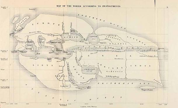
19th century reconstruction of Eratosthenes’ map of the known world, 194 BC. (Public Domain)
The Roman approach to cartography was typically practical. Rather than the pursuit of knowledge Roman cartography served had two applications: military and administrative. Most of their maps were limited to “Mare Nostrum,” the core of the Roman Empire, and were used to lay out administrative boundaries, physical features, and roads.
Special Mention: The Ptolemy Map
The most important map of this era is perhaps the Ptolemy map due to the role it played in Roman expansion. The map was based on the information contained within the Geographica, written by the Alexandrian Ptolemy. In it, the great polymath refers to an early system of longitude and latitude as well as a way of describing locations based on astronomical observations made from these areas. Basically, working out where you are by observing the night sky.
While known as Ptolemy’s map, it’s believed the map itself was created by Agathodaemon of Alexandria but included in the Geographica. Sadly, the original maps were lost but the work was so descriptive that later cartographers were able to recreate the Ptolemy map. Both the map and the Geographica went on to inspire countless later cartographers across the world.
Ancient China
We would be remiss to ignore advances made by early Chinese cartographers. Throughout its various dynasties advancements were made and in 605 AD one of the first maps using a grid system was drawn by Pei Ju of the Sui Dynasty. In 801 AD, during the Tang Dynasty, an accurate map of China and its Central Asian colonies was created, the “Hai Nei Hua Yi Tu”. This impressive piece was 30 feet (9.1m) by 33 feet (10m) and used an incredibly accurate (for the period) grid system.
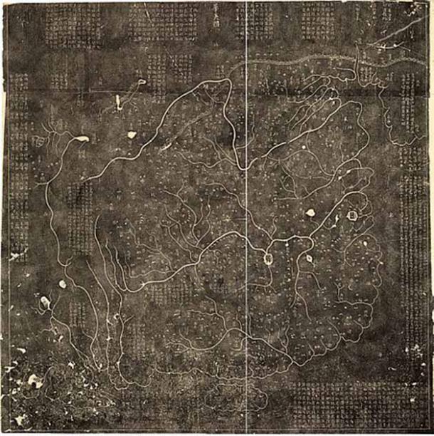
A 1933 Rubbing of the Huayi Tu Stele from the Library of Congress. (Public Domain)
Maps of the Middle Ages: Arab World
Great strides were made in map-making during the Middle Ages, largely by Muslim scholars who advanced on the mapmaking of the cultures that had come before them. They began by following Ptolemy’s methods and combined them with the knowledge and writings of the many explorers and merchants who were striking out and traveling across the Muslim world as trade routes expanded.
The Arab world is famously the home of mathematics, and they made great leaps in using more accurate definitions of units of measure and expended much effort trying to define and calculate the circumference of the earth, getting much closer than Eratosthenes had. Likewise, during this time Arab cartographers worked hard to create their own system of accurate meridians and parallels (the grid systems used by cartographers).
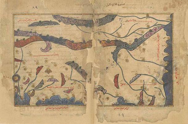
Map of al-Maghrib al-Aqsa and al-Maghrib al-Awsat in the oldest known surviving manuscript copy of Idrisi’s Tabula Rogeriana. (Public Domain)
In 1154 AD the Tabula Rogeriana was published by Al Idrisi, an Arab geographer. Commissioned by King Roger II of Sicily and Africa, it took 16 years to create, and the atlas is made up of 70 maps. A masterpiece of its time, the work doesn’t just form a map of the world, it’s a geographical text that has everything from natural features to information on ethnic and cultural groups, economies, and much more.
The Tabula was based on Al Idrisi’s travels as well as interviews with other explorers and included the work of draftsmen Idrisi paid to travel and map their routes. Impressively, the atlas depicts the world as a sphere, breaking it up into 70 rectangular sections.
European Efforts
By the 1300s the Europeans were getting rather good at making their world maps, known as “Mappa mundi”. The most impressive of these is probably the Hereford Mappa Mundi which is both the largest surviving medieval map in existence and one of the most elaborate.
This map has Jerusalem at the center, emphasizing the era’s religious focus, and has the Garden of Eden in a ring of fire at the top. If this isn’t strange enough, the map also has Africa labeled as Europe and Europe as Africa (no one seems to know why). The map itself is circular although this doesn’t necessarily mean its cartographer was a flat-earther. Instead, it’s believed to be a kind of projection, meaning it’s more of a representation of the world’s habitable areas rather than a true world map.
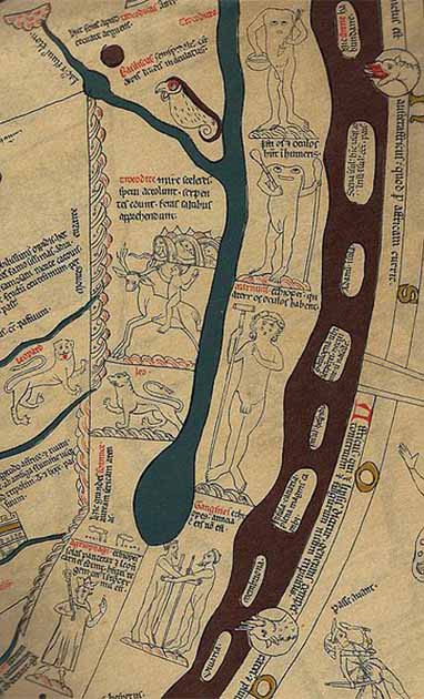
Detail of the Hereford Mappa Mundi, showing Africa south of the Nile River. A Troglodyte rides a goat-beast, and headless Blemmyes. (Public Domain)
One of the most advanced Middle Ages maps is the Fra Mauro Map, drawn by Fra Mauro, a monk, in 1450 AD. This massive map, six and a half feet (two meters) in diameter was painted on vellum and stretched over a wooden frame. It‘s a surprisingly accurate representation of Europe, Asia, and Africa but has one odd feature. It’s orientated with the south at the top, unlike most maps of the time (which were still taking inspiration from Ptolemy’s map). This is because Fra Mauro felt the Ptolemy map was based on old data and his contemporaries were too reliant on it.
Early Modern Period: Europe
The next big jump came during the Early Modern Period, a time marked by remarkable events like the Renaissance, Age of Exploration, and Protestant Reformation. Printing alongside the development of new surveying methods and new, more accurate instruments led to better maps, and cartographers themselves became people who wielded real influence.
As trade routes expanded even further, Europeans tried to colonize more and more of the world and military campaigns spread further afield, rulers became more aware than ever that they needed more accurate maps. It’s difficult to lead an offensive when your navy doesn’t know where to land and your army doesn’t know where it is safe to march after all. You also can’t colonize a place if you can’t find it.
One of the big names in cartography during this period is the Flemish geographer, cartographer, and cosmographer Gerardus Mercator. In 1569 he published the Mercator Map, arguably one of the most important maps in maritime history. It sought to solve the problem inherent in representing a round earth on a flat piece of paper, which tends to distort everything- in particular, the lines of latitude and longitude used for navigation.
The Mercator map allowed for straight lines, known as loxodromes, which made it incredibly useful when navigators were trying to chart a course. In 1570 cartographer Abraham Ortelius used these maps in his Theatrum Orbis Terrarum. Notable not just for using this new mapmaking methodology, this atlas is famous for mainly using maps based on contemporary information rather than focusing on old data like the Ptolemy Map.
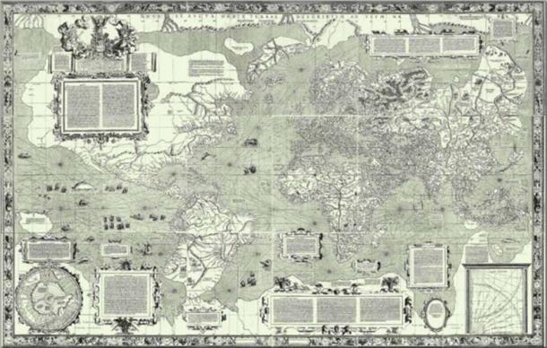
Mercator 1569 world map. (Public Domain)
Asia and the Americas
Of course, it wasn’t just in Europe that advances were made. Cartography continued to develop in the East as well. 1579 saw the creation of the Guang Yutu atlas which contained more than forty maps. It showed important landmarks like road systems, and mountain ranges and highlighted the borders between different political areas in Asia.
The 1500s were also significant because this is when the first maps of the Americas came to be. Created by Juan de la Cosa, an explorer and Cartographer from Spain, these maps used information he gathered while traveling alongside Columbus. He also drew some of the first maps that included the Americas, Africa, and Eurasia all on the same map. This period also featured Diogo Ribeiro designing the world’s first “scientific” map, the Pardon Real, which accurately showed the coasts of Central and South America.
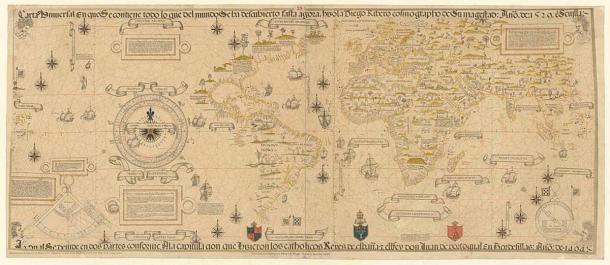
Facsimile of Diogo Ribeiro’s 1529 Carta Universal. (Public Domain)
Modern Cartography: Post-Industrial Revolution
Working on the groundwork laid down over thousands of years the last two hundred years or so has seen rapid advancements in cartography. The advent of printing presses and lithography during the Industrial Revolution facilitated the mass production of maps, making them more accessible to the public. The 19th century saw the development of topographic mapping techniques, notably with the Ordnance Survey in Britain and similar initiatives worldwide, resulting in highly detailed and accurate maps for various purposes.
The 20th century brought about revolutionary changes with the introduction of aerial photography, satellite imagery, and Geographic Information Systems (GIS), enabling cartographers to create more precise, dynamic, and interactive maps. The digital age further accelerated the evolution of cartography, with the rise of computer-assisted mapping tools, GPS technology, and online mapping platforms like Google Maps and OpenStreetMap. Today, cartography continues to push boundaries with advancements in 3D mapping, augmented reality, and real-time data visualization, shaping how we perceive, navigate, and interact with the world around us.
Conclusion
From ancient Babylonian clay tablets to the sophisticated digital maps of today, cartography has evolved significantly over millennia. Innovations driven by exploration, scientific inquiry, and technological progress have revolutionized the way we perceive and navigate our planet.
Today most of us carry around an almost pinpoint accurate map with us everywhere in the form of either Google or Apple Maps. Knowing where we’re going is something we take for granted and getting lost is almost a thing of the past. We owe this to the brave explorers and diligent cartographers of the past.
Let’s hope that in our complacency we don’t lose that relentless curiosity and sense of exploration that drove our predecessors. If humankind continues to explore, it will need cartographers- whether it be the bottom of the deepest oceans or new horizons on new planets.
Top image: Facsimile of Diogo Ribeiro’s 1529 Carta Universal. Source: Public Domain
By Robbie Mitchell
References
Dempsey, C. 2011. MAPPING THROUGH THE AGES: THE HISTORY OF CARTOGRAPHY. Geography Realm. Available at:
Briney, A. 2019. The History of Cartography. ThoughtCo. Available at:
Moulton, M. 2021 . MAPPING THE WORLD: A SHORT HISTORY OF CARTOGRAPHY. History Guild. Available at:
Jones, A. 2024. Ptolemy. Encyclopedia Britannica. Available at:
Source: www.ancient-origins.net

